
HISTORICAL GOLD PRODUCTION
Wedderburn
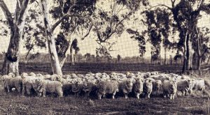
Wedderburn is located at 189 m above sea level in forest and open farmland 214 km NW of Melbourne and 74 km East of Bendigo. Prior to European settlement, the area was occupied by the Dja Dja Wurrung. Today Wedderburn is a small country town on the Calder Highway about two and a half hours’ drive north-west of Melbourne with a population of approximately 600. The region’s economy is characterised by agricultural production, with most of the local labour force employed in this industry.

Mining History
Historical production from WGL’s tenements totals approximately 150,000 ounces of gold, comprising 25,000 ounces from shallow shafts within the field’s 33 km of known quartz reefs, and a further 125,000 ounces from alluvial workings.
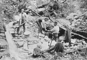
Gold was first discovered at Wedderburn by a shepherd named Brady in 1852. The field was first known as Korong or Mount Korong. Quartz mining quickly followed the discovery of alluvial gold, and the first public crushing plant was erected in 1859.
The Wedderburn township was surveyed in 1856/57, and allotment sales began in 1858. The town is likely named after William Wedderburn, an officer who served in the Goldfields Mounted Police.
During the peak of the gold rush, there were some 6,000–7,000 gold prospectors in the area. But this number dwindled quickly because of the lack of water for mining, the lack of funds for prospecting, and the discovery of other nearby goldfields.
Potential
The Geological Survey of Victoria in 1911 concluded: “I am convinced large amounts of gold remain above the [ground] water level… there are scores of outcropping indicators on which a shaft has never been sunk.
I have no doubt the surface auriferous features will be found repeated below [ground] water level… the failure has been due more to the want of funds, than to the productiveness of the reefs.” (Whitelaw, 1911, p. 30).

Nuggets
The field has a rich alluvial gold nugget endowment and produced a total of 150k oz of gold, with a modest amount from underground. (Whitelaw, 1911). As a result, the Wedderburn area is presently very popular with metal detector operators.
Many shallow underground quartz lode mines exist on the Tenement. (Whitelaw, 1911).
Many auriferous reefs occur across the whole goldfield. Those within the Western and Central clusters have multiple kms of strike length but there has been very little modern exploration with limited drilling – 89 shallow holes, only three deeper than 60 metres.
The ground is noted as being heavily faulted, which creates an excellent opportunity for gold exploration. (Whitelaw, 1911, p. 15).
Wedderburn – Hot and Cold
Although the Wedderburn Goldfield attracted thousands of prospectors, miners repeatedly abandoned the area due to a lack of permanent water.
May 1852
 Gold first discovered at Welshman’s Point, Golden Gully, Wedderburn by a shepherd named Brady.
December 1852
 6,000 to 7,000 men on the field – alluvial gold.
June 1853
Less than 100 men remain on the field due to the want of water for mining. First quartz miners sink a round shaft.
June 1855
Heavy rains attract 800 men to the field. No new ground discovered. Population drops to 400 men.
November 1855
 “Smith’s Patch” opened – alluvial gold – every man on the field is on payable ground.
December 1855
 Unusually rich gullies and flats attract a large population again – numerous new gullies discovered.
December 1856
Lack of funds causes most mines to close prematurely.
Wedderburn – Public Companies
- May 1859: First public crushing plant located at Steel’s Gully.
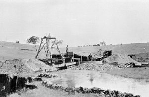
- Public company development of quartz reefs below water level was retarded by lack of success.
- Gravels have been very productive of alluvial gold, though the large amount taken from Wedderburn was not accurately recorded.
- 22 large nuggets were recorded between 1853 and 1889. They ranged in colour from blue to black, and from 1,400 grams to 9,525 grams.
- Total weight: 67,358 grams. Today’s price: A$5,255,944.
- The Wedderburn beds “have been faulted and fissured to a remarkable degree.”
- “Unfortunately, it very frequently occurs in these mines, that, when gold is lost, prospecting carries on a very disorganised way.”

Drought ends the dream
Goldrush mining operations on the Wedderburn field were halted when severe droughts in the late 1800s dried up water sources vital for gold extraction, crippling goldfields across northern Victoria and forcing many miners to abandon their claims. This lack of water made it impossible to continue mining activities, dramatically impacting remote mining communities like Wedderburn throughout the region.
Even large goldfields like Bendigo were impacted by severe droughts.
“…Unless means are at once taken to supply the miners of this district with water for working purposes, many thousands of that class and those connected with it will be subjected to great privation if not reduced to utter destitution.”
John McIntyre, Mayor of Sandhurst (Bendigo), writing to the Minister of Mines for the Colony of Victoria, in 1866.
Wedderburn – future mining
December 1905:
“…probably not more than half-a-dozen legitimate reef prospectors remain on the field.” “Public mining companies have operated on reefs in the district, but in no one instance has work been profitable and their funds have not lasted long enough to allow stone to be cut.” “I am convinced large amounts of gold remain above [ground] water level… there are scores of outcropping indicators at the source of rich alluvial gullies on which a shaft has never been sunk.”
O. A. L. Whitelaw,
The Wedderburn Goldfield, Geological Survey of Victoria, 1905
Historical gold production at Wedderburn
Historical gold production statistics for Wedderburn are mostly inaccurate and unreliable. Edwards et al (2001) estimated 115,954 oz au was derived from alluvial deposits, but this is almost certainly a gross underestimate. Metal detectorists have found many unrecorded nuggets in the last 40 years.
| SOURCE OF GOLD | MINES DEPT RECORDS | REFERENCES | ESTIMATES | TOTALS | TOTALS |
| KG | KG | KG | OZ | KG | |
| QUARTZ REEF | 380.0 | 340.7 | 63.8 | 25,223 | 784.5 |
| WASH DIRT | 342.0 | 0.0 | 3,110.0 | 110,986 | 3,452.0 |
| CEMENT | 1.6 | 0.0 | (INCLUDED IN WASHDIRT) 0.0 | 52 | 1.6 |
| TAILINGS | 27.4 | 0.0 | 0.0 | 880 | 27.4 |
| NUGGETS | 0.0 | 90.9 | (METAL DETECTING) 62.0 | 4,916 | 152.9 |
| TOTAL | 142,057 | 4,418.4 |
Table: historical gold production at Wedderburn.
References are primarily Gray (1891), Whitelaw (1908A, 1911), Moon (1896)