EXPLORATION UPDATE
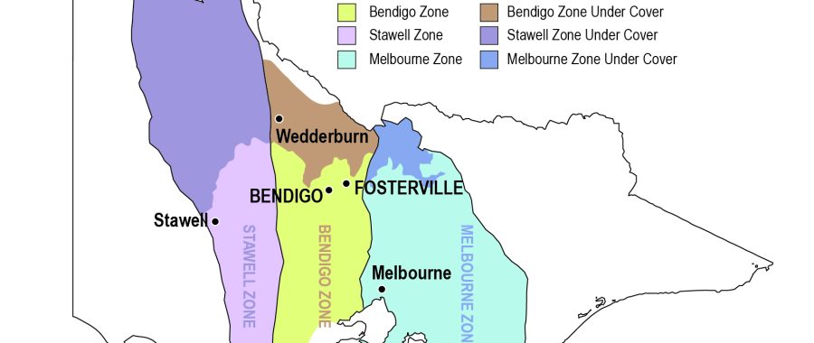
This is an update on the promising and successful project work carried out by Wedderburn Goldfields Ltd (WGL) via its wholly-owned subsidiary PSD Minerals Pty Ltd (PSD) on its 100% owned, 47 square-kilometre Exploration Licence 6302 (EL) within the geological area of Central Victoria known as the “Bendigo Zone” which has produced 63 million ounces of gold.
Modern exploration techniques are being utilised on the EL for the first time.
Summary
Work within EL 6302 has shown the following:
- The Castlemaine Group, which are host rocks for gold mineralisation in all the largest central Victoria fields, are also present at Wedderburn
- Discreet dilation zones (structural voids and faults) have been identified that are similar targets to those that produced the most gold in the Bendigo Zone.
- The presence of underlying deep faults allowed orogenic gold fluids to invade near-surface faults and voids.
- Underlying rocks have distinct magnetic readings unique to Central Victoria.
- pXRF measurements have identified individual mineral elements within the host rocks
- Detailed logging and interpretation of core sediments have revealed the type and position of geological structures and sedimentary facies.
- The intersection of targeted geophysical faults in the drilling campaign, thereby ground-proofing/truthing the geophysics.
On-ground mapping.
Clive Willman & Associates (Willman) carried out detailed structural geological mapping, which has ground-proofed the early 20th-century mapping of OAL Whitelaw and provided new structural data.
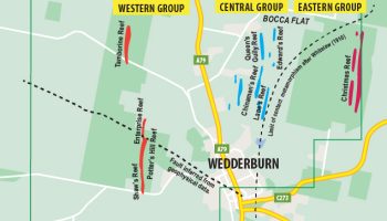
Based on this work, Willman showed that Wedderburn’s reefs within EL 6302 are clustered in three areas called the Western, Central and Eastern groups. (See Fig.1)
Castlemaine Group sedimentary rocks are the primary host for most major gold production in the Bendigo Zone. The recent mapping and diamond drilling at Wedderburn shows these rocks are present within EL 6302.
The correct rocks are present within EL 6302 to allow gold to be found – Castlemaine Group.
The second round of drilling completed.
A second round of diamond drilling was completed in early September 2022. The program included drill holes DH001 to DH004, totalling 1600 metres in drill length, located within a drill corridor with a strike length of 1.75km. Preliminarily, logging and interpretation of the core were completed at a rented core shed in Inglewood.
All the core was photographed, and where relevant, the core was prepared, cut and dispatched for assay. The highest assay received was 3.9g/t gold in LDH 002 from what is believed to be Lanes Reef. Other assays showed that various geological shoot structures contain gold over the full drill corridor strike length of 1.75 km. Final assays were last received in December 2022.
Aim of exploration
The initial 3,317-metre diamond drilling program aimed to establish the location of discreet underground geological structures and to gather data regarding the nature, geometry and evolution of these geological structures. This program was considered important because very little historical deep and/or oriented diamond drilling had been carried out within EL 6302 – only eight historic diamond holes have been drilled, with only three extending below 50 metres.
The geological information gained from the various core interpretations is being used to design a future drill program that will target the anticipated discreet gold shoots similar to those widely found elsewhere in the Bendigo Gold Zone.
Discreet gold-bearing structures
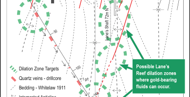
Based on the information so far, gold shoots and dilation zones within EL 6302 are thought to be related to fold hinge zones, such as anticlines and synclines, and faults that cut across the intervening limbs between the fold hinges.
These types of geological structures (dilation zones) have produced the most gold within the Bendigo Zone, but they are not the only type of dilation zone targets explored within EL 6302. (See Fig. 2)
Dilation zone targets that have produced the most gold in the Bendigo Zone are present within EL6302.
Source of Gold in the Bendigo Zone
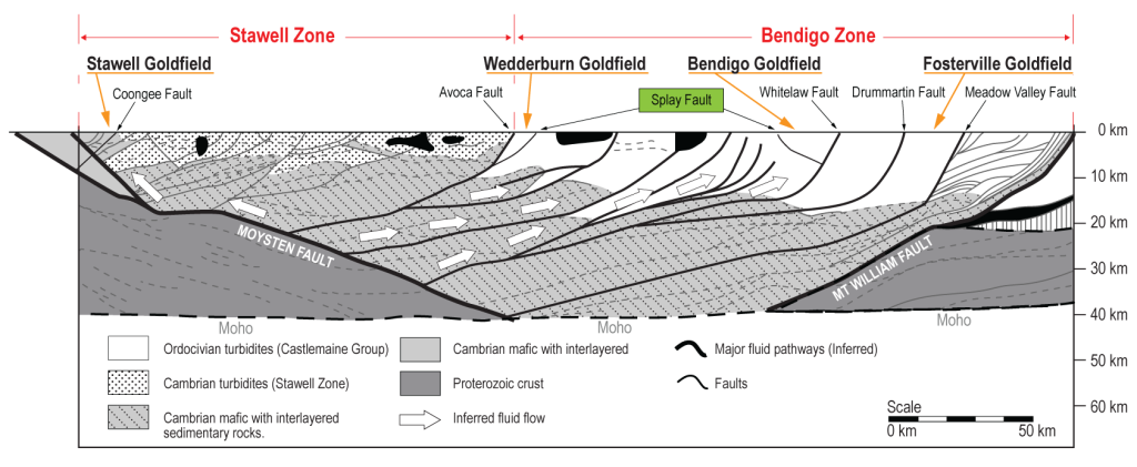
The Geological Survey Victoria (GSV) has interpreted the seismic line that crossed Victoria from West to East and which passed just 26 km south of EL 6302. The GSV interpretation shows two splay faults, one below the Bendigo Goldfield (gold production of 22 million oz of gold) and another below the Wedderburn Goldfield. (EL 6302) The splay fault interpreted under EL 6302 may be the source of the deep orogenic gold fluids that have entered the near-surface faults and voids in the goldfields of Wedderburn. (EL6302) (See Fig 3.)
Note the Castlemaine Group sediments overly the deeper interbedded Cambrian Volcanic and sedimentary rocks, believed to be the source of orogenic gold in the Bendigo Zone and within EL6302. (See Fig3)
El 6302 is underlain by deep faults, allowing orogenic gold fluids to deposit in near-surface faults and voids within EL 6302.
Use of modern exploration methods.
Modern interpretative exploration techniques, magnetic, conductivity and pXRF measurements were carried out between February and July 2023 by contractors on a total of 3,317 metres of diamond drill core.
Magnetics
EL 6302 and its surroundings have a unique magnetic signature in the Bendigo Zone. Individual magnetic measurements can be taken for different rock types; it is found that each rock type (lithology) has its distinct magnetic signature.
This unique phenomenon has allowed an accurate lithological (different rock types) log for all the core to be developed, and together with conductivity measurements, will aid future remote exploration techniques to be used in EL 6302, such as IP surveys.
Eight different rock types underlying EL 6302 have their own distinct magnetic reading. (Fig. 4)
Portable X-ray fluorescence analysers (pXRF).
One application of the pXRF measurements is to ascertain if the many laminated quartz veins found in the core have their subtle differences; if so, then these distinct laminated quartz reefs may be tracked more accurately from drill section to drill section, assisting in gaining a more accurate interpretation (position) and type (i.e.-anticline/syncline) of relevant geological structures along the drilling program strike of 1.75km.
pXRF measurements allow individual assemblages within the rocks to be identified.
Particle size sedimentary interpretations
In addition to the preliminary core logging, specialised structural and sedimentary logging of all the 3,317 metres of core (took place at the core farm, not undercover, with core trays on pallets) commencing in June 2023 and completed late in August 2023, with the anticipated final interpretation of this logging and construction of the 3D model to be completed in October 2023.
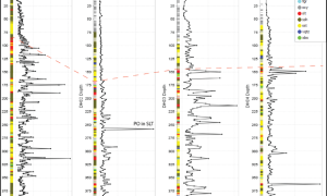
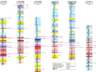
An example of one of the sedimentary correlation plots that form the basis for the geological reconstruction is (See Fig.5.), included to illustrate this interpretative technique and to note the use of modern exploration techniques and interpretation methods in order to best interpret exploration data, which can be used to target future drilling campaigns of the anticipated discreet dilation zones.
A sedimentary correlation plot is used to interpret the type and position of geological structures underground.
Geophysics
Interpretation of the available geophysics has been used within EL6302 and its surrounds to create the linear (interpreted) position of the many types of geological structures present within EL 6302.
PGN Geoscience (PGN) has interpreted Victorian aeromagnetic data and created maps depicting many exploration targets’ ground positions.
Noting the positions of known auriferous reefs and plotting the N-S striking linear (interpreted) D1 &D2 faults and fold hinges (logged in the core as west dipping) and the linear cross structures (NE and NW striking) D3& D4 faults, it has been possible to plot the many potential intersections of these geological structures, all of these intersections (268) warrant further exploration (See Fig.7 below).
Note that D1 & D2 faults have been logged in the core whilst diamond drill holes LDH002 and DH003 were designed to intersect, and did, respective D3 & D4 cross faults, thus ground proofing/truthing the geophysics giving credence to the geological structural interpretation delineated from the geophysics. (See Fig 6 below)
Intersection of linear cross reef.
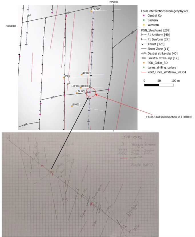
The southern end of the central corridor (Lanes) with geophysical structural interpretation and drilling. The drill traces are shown in white with LDH002 intersecting a WSW-ENE structure at ~38 m depth; b) Correlating fault intersection in the physical logging of LDH002 from Rodney Fraser.
Interpretation of the geophysics has noted a strike length of:
- 33 km of mapped auriferous reefs
- 177.6 km of N-S trending potentially gold-bearing faults and fold hinges
- intersections of fault-fault, fault-fold hinge and local cross-faults (268)
Intersections of auriferous reefs
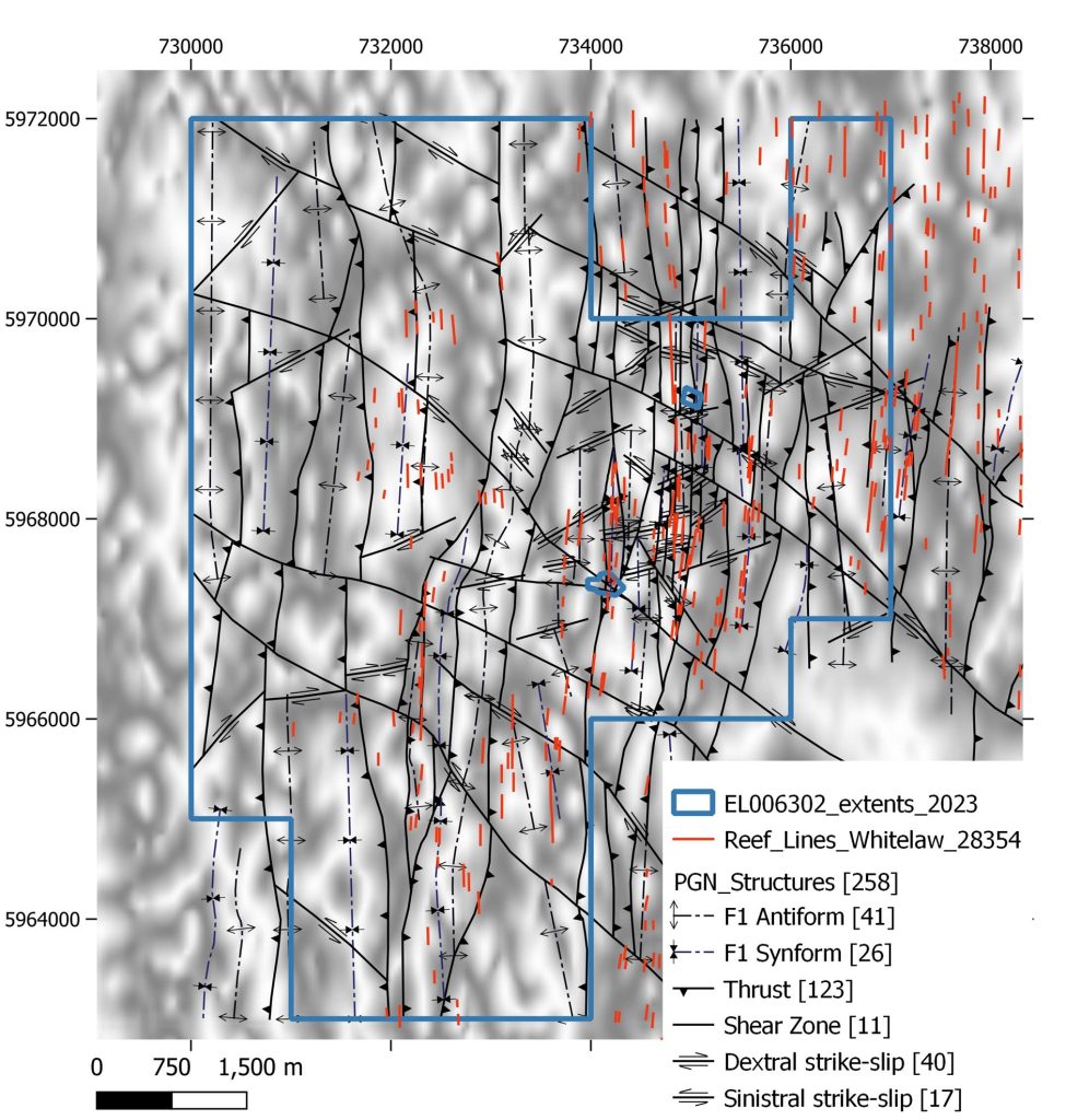
PGN Geoscience notes that “in addition to 33 km’s strike length of mapped auriferous reefs, 177.6 km’s strike length of N-S trending potentially gold-bearing faults and fold hinges were interpreted for EL 6302, many of these sites were further interpreted as either fault-fault or fault-fold hinge intersections.
The recent diamond drilling program targeted and intersected two of these interpreted fault-fault sites; in LDH 002, an interpreted fault-fault intersection is characterised (from the core) as a narrow zone of quartz veining but has no distinct geochemical or petrophysical signature. However, a pronounced fault-fault intersection in DH003 (from the core) correlates with a significant and wide zone of Arsenic enrichment, elevated potassium and sodium, and isolated gold anomalies in assays and pXRF data sets. … This provides a good indication that these sites (the many intersections) are likely zones of localised dilation during hydrothermal events, including mineralisation, and warrant further investigation.”

