WGL Shareholder Update.
This shareholder update describes the success of the Wedderburn Goldfields Ltd (WGL) proof-of-concept diamond drilling program, which dramatically changed the company’s understanding of Wedderburn’s geology. WGL has now developed a new interpretation of the structural geological setting of the Wedderburn Goldfield.
- WGL interprets its exploration data to show a series of regularly spaced major anticlines and synclines across its tenements that are essential for forming the high-grade discreet dilation zones that have produced the most gold within the 65 million-ounce Bendigo Zone.
- This interpretation is based on:
-
- Ultra-detailed sedimentary and petrophysical logging.
- Recognition of a major regional syncline in the 1.75 km drill corridor in the Central Zone.
- Specialist structural geological mapping.
- Drilling that ground-proofed reinterpreted geophysics.
-
Pathfinder minerals, including arsenic and carbonate spotting, have been found in an anticline/syncline reverse fault setting, which will allow WGL to more confidently plan its search for discreet, in size, high-grade gold dilation zones.
What does a historic central Victorian goldfield look like?
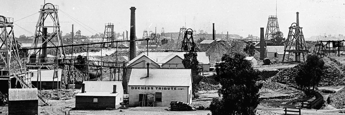
The northern end of the Bendigo Goldfield looking south circa 1895. The Bendigo Goldfield contains 37 gold-bearing quartz reefs extending 16 km by 4 km. More than 5,000 mines operated in that area. Because of its scale and success, the Bendigo Goldfield readily attracted capital/funding. It involved many discrete in size and highly profitable mining leases. The majority of Bendigo’s gold production came from discrete gold zones, which essentially breached anticlines and synclines associated with reverse fault structures.
Mining leases in Bendigo were small. It is a saddle reef field with discrete in size, high-grade dilation zones that repeat semi-regularly at depth.
The Bendigo field’s gold production totalled at least 22 million ounces at an average gold grade of about 15 g/t recovered.
Wedderburn has all the essential geological characteristics of a significant central Victorian goldfield like Bendigo:
- A now predictable system of major, regional anticlines and synclines associated with reverse faulting.
- Important transverse cross-faulting.
- An aggregate of 33 km of auriferous reefs, mined from 1851 to the 1860s, mapped by Whitelaw in 1907 and ground-proofed by Willman in 2022.
- 178 strike km of fault-fault and fault-hinge zone structures.
- Extensive zones of anomalously high readings of arsenic, a well-known pathfinder for gold deposits.
- Carbonate spotting observed that is typically only found associated with significant gold deposits.
What do anticline/syncline reverse faults look like?
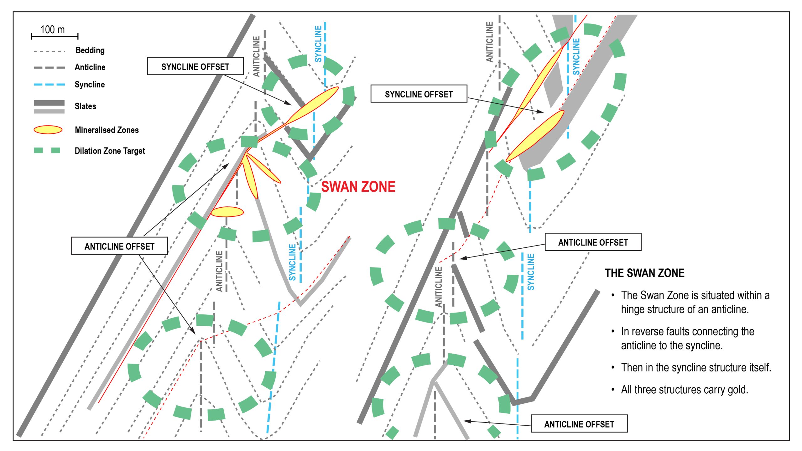
The geological structure depicted in the schematic above is typical of the exploration focus/target of the 5000+ shafts in the Bendigo Goldfield and is the focus for the 258 targets at Wedderburn.
WGL’s proof-of-concept diamond drilling has now:
- Spatially positioned regional anticline/syncline structures for the 1.75 km of the drill corridor.
- Determined an exploration strategy to allow a more accurate search for high-grade-gold dilation zones that form in the anticlines and synclines.
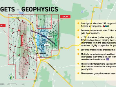
- Ground-proofed the geophysics to allow 258 geophysical targets to be prioritised for future exploration.
- Geophysics has interpreted a series of N-S projected anticlines and synclines for the whole area of WGL’s exploration tenements.
- Knowing the position of anticlines and synclines aids in the exploration for high-grade gold.
What did WGL start with?
Historic underground mining began at Wedderburn on reefs like Lane’s Reef, which outcropped on the surface at the southern end of WGL’s drill corridor. Miners focused on chasing outcropping reefs that never developed into regional geological structures. For example, Lane’s Reef, which outcropped on the surface, was only mined to a depth of 50 m.
Historically, it was thought that old workings in the Lane’s Reef area, where the most geological data was available, were associated with a series of anticlines.
Whitelaw’s 1907 plan view of Lane’s Reef area.
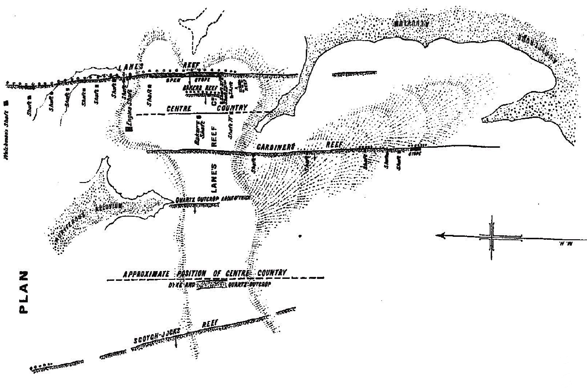
Note: “centre country” marks the surface position of the hinge zones of two anticlines, which are now interpreted as parasitic folds on the western leg of the regional syncline.
What do we have now?
WGL has defined a major regional syncline extending over the full distance of the 1.75 km drill corridor in the Central Zone. This has come from defining key geological features, like marker beds from sedimentary logging, to establishing a high-priority regional syncline target here for the first time. It has been associated with high arsenic geochemistry and carbonate spotting, which are proven pathfinders for Bendigo Zone-style high-grade gold deposits. Most gold from the Bendigo Zone has come from dilation zones, which are breached, discrete in size, and anticline/syncline-associated reverse fault structures.
Examples of prospective targets.
Anticline Targets.
It is now clear that the old workings associated with the interpreted position of the anticlines on either side of the regional syncline were not developed deep enough by historic mines to explore their setting or intersect the interpreted structure. WGL’s drilling, which has led to the interpretation of the regional syncline, has given the company great confidence in predicting the position of the east and west anticlines.
Because the historic high-grade gold intersection on the Gowk’s Hill Reef Line depicted in the schematic below is within the hinge zone of the anticline, this anticline becomes a target for WGL’s exploration.
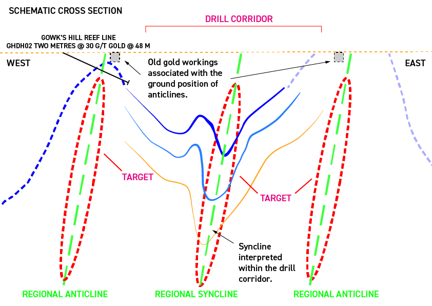
Note: Spatial geological measurements derived from modern exploration techniques accurately position the east and west anticlines associated with the newly interpreted regional syncline, allowing targeted exploration for high-grade dilation zones.
Syncline Targets.
The diamond drilling results have been interpreted to expose a regional syncline associated with spasmodic parasitic folding running the full distance of the drill corridor. The interpreted regional syncline will now be explored by directional diamond drilling for the first time.
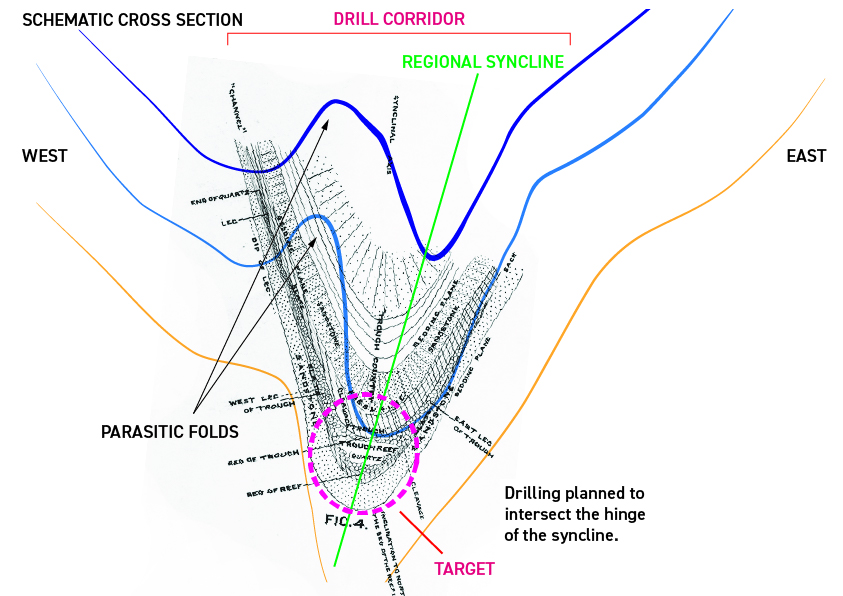
Note: The target area is the hinge of the syncline. It runs for the full distance of the drill corridor and has never been explored.
Summary
WGL’s proof-of-concept drilling has established an unexplored regional syncline associated with pathfinder minerals like arsenic and carbonate spotting for 1.75 km in the drill corridor. This structure is related to regional-scale anticlines east and west of the drill corridor. These geological structures are required for the formation of gold-bearing dilation zones, which can now be the target for future exploration.
Recent examples of central Victorian high-grade discreet dilation zones:
- The 2.7 million ounce Swan Zone at Fosterville had a strike length of some 200 metres, an average width of 2 metres (it pinched and swelled along strike), and a depth of some 400 metres, BUT it was found 800 metres underground with no surface expression.
- The Nick O’Time shoot at Tarnagulla was 70 metres underground with no surface expression. It had 60 metres of strike length, was 10 metres wide in the centre, and narrowed to virtually nothing at the perimeters. It was 350 metres deep and produced 54,000 oz of gold from 56,000 tonnes of ore.
Each of the Bendigo Zone’s goldfields has distinct high-grade discreet dilation zones, but all are geologically structurally controlled in their formations. WGL’s proof-of-concept diamond drilling campaign has successfully located the regional spatial position of the geological structures necessary to form the discreet high-grade gold dilation zones, allowing for their targeted exploration.

![2024-NOV-BHISTORIC-SHAFTSArtboard 1-100 Map of Bendigo Goldfield overlayed with the location of its 5000+ shafts [successful targets] (Willman 2024).](https://wedderburngoldfields.com.au/wp-content/uploads/2024/10/2024-NOV-BHISTORIC-SHAFTSArtboard-1-100-400x300.jpg)
