EXPLORATION INFORMATION
This is a summary of the exciting and successful project work carried out by Wedderburn Goldfields Ltd (WGL) via its wholly owned subsidiary PSD Minerals Pty Ltd (PSD) on its 100% owned, 51 km² Exploration Licences 6302 and 8296 (EL). Modern exploration techniques are being utilised for the first time to expand exploration targets anticipated to be delineated by a suite of state-of-the-art exploration tools, including geological outcrop mapping, diamond core structural logging and geophysics, including magnetic susceptibility and conductivity measurements together with X-ray fluorescence (XRF) analysis. Specifically, the company will employ magnetics and conductivity to trace the presence of gold-bearing “dilation zones” within the EL, which is situated in the geological area of Central Victoria known as the Bendigo Zone.
Under-developed Goldfield
Wedderburn is one of Victoria’s under-developed goldfields, it has a geographical footprint comparable to other moderate-sized goldfields in the Bendigo Zone. Clive Willman & Associates (Willman) geological mapping (bedding, cleavage & younging) of the surface outcrops on the EL has classified various clusters of united reefs into Western, Central and Eastern Groups as depicted in Figure 1.
Western Group
The Western Group has clusters of auriferous reefs in the south, including Shaw’s Reef, featuring the New Caledonian Mine, which produced the most recorded shaft-gold on the Wedderburn goldfield. The Potter’s Reef clusters include an “addit” (horizontal shaft into a side of a hill). The Enterprise cluster of reefs has several shallow shafts, as does the Tambourine cluster of reefs. The Western Group has a strike length of some six kilometres.
Central Group
The Central Group of auriferous reefs includes Lane’s Corridor, the subject of WGL’s 2022, 3317 metre diamond-drilling program described in Exploration Information No 3 Dec 22. As well as the “Lanes Corridor” reefs, and other reef structures, the Central Group of auriferous reefs include Bocca Flat, where much alluvial gold was extracted historically and currently, by modern day metal detector operators. A local resident is quoted as saying, “when the Bailiffs at the door I take the metal detector to Bocca Flat it has never failed me yet!”
Eastern Group
The Eastern Group of auriferous reef clusters include the Old Christmas, Buckeye, Robinson’s, Annie Jone’s and Shamrock Reefs. All these reefs have shallow shafts, only to the depth of the water table, (say 50m) with historically noted anticlines, synclines and cross reefs. (As in the Western and Central Groups).
There are many “lineaments” (interpreted cross faults) situated on the EL resulting from the current diamond drilling exploration results. Geophysical exploration techniques will now be focused on the 10km strike length of unexplored auriferous reefs which have never been subjected to modern exploration.
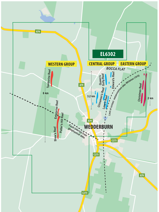
Figure: From Clive Willman & Associates’ map showing the Western, Central and Eastern Groups of auriferous reefs never subjected to modern exploration techniques.
Dilation Zone Targets
The world-class, cumulatively large and very high-grade, discreet gold deposits in the Central Victorian Bendigo Zone, sourced from the Castlemaine Group turbidites.
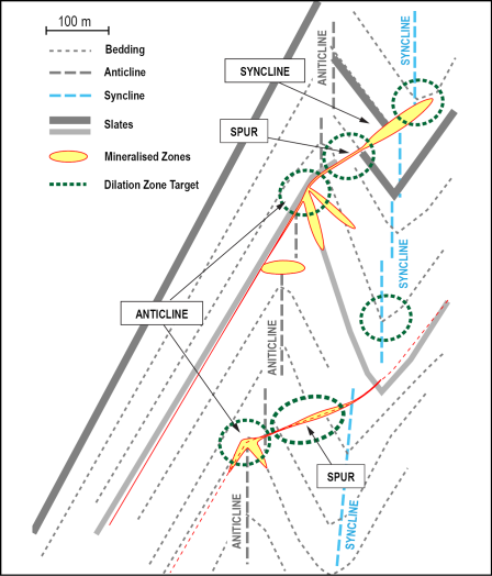
All occur in distinct geological structural settings known as dilation zones as shown in the figure at right, of which there are various forms.
WGL is initially searching for gold within three main types of dilation zones. These have proven to be prolific gold producers in the Bendigo Zone.
These initial three forms of dilation zones are:
- Hinge zones in anticlines – probably the greatest amount of gold has come from these structures in the Bendigo Zone;
- Spur zones (a mesh-like arrangement of quartz-filled tension veins that were often very significant bodies of gold mineralisation) situated between anticlines and synclines; and
- Hinge zones of synclines, which historically were neglected, but are a significant feature of the very high-grade Swan Zone at Fosterville and the Nick ‘O Time shoot at Tarnagulla.
2022 Diamond Drilling
WGL successfully completed a circa 3,317 metre diamond drilling campaign centred on Lane’s Corridor.
This Central Group of reefs was chosen for detailed exploration because more data existed, not because it was considered more prospective.
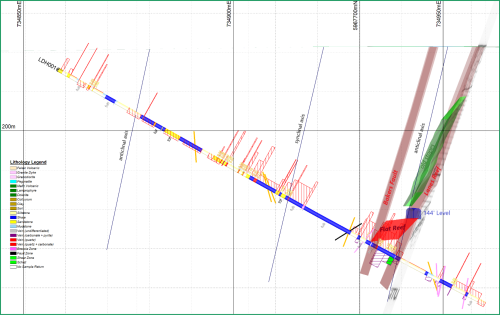
Twelve holes, LDH 001 to 011, were drilled in the central group of auriferous reef clusters (LAne’s Corridor) at flat angles circa azimuth 30° with downhole lengths of 120-150 metres.
Four holes, DH 001 to 004 were drilled at azimuth angles of 51° with downhole extents of about 400 metres.
For all 16 diamond drill holes, the drill core has been:
- logged (interpretation continuing),
- subjected to magnetic susceptibility and conductivity measurements – completed in late November 2022.
The drill core will be subjected to further testing and review comprising:
- a follow-up review of geological structural features as detailed interpretations of all results are completed and will be incorporated into an updated 3-D model,
- handheld X-ray fluorescence (XRF) measurements to test for any anomalous geochemical features in the core,
- detailed geological structural logging (underway).
Core Logging
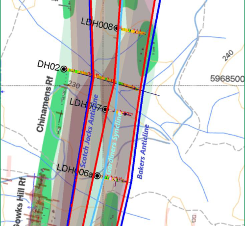
Interpretation from the core logging, has established the structural setting of Scotch Jock’s, Gardiner’s, and Baker’s anticlines for a strike length of 1.75 km.
Noting that Gardiner’s, Baker’s and Lane’s Reefs are north plunging from the southern end of Lane’s Corridor whilst the plunge of the reefs in the north of Lane’s Corridor is more difficult to determine.
Whilst several quartz reefs have been intersected in the north of Lane’s Corridor, they have only tentatively been interpreted as Gardiner’s, Baker’s and Lane’s Reefs.
Modern exploration tools to define more targets
Memoire 10 -1911 (Whitelaw) noted that many and varied faults exist within the goldfields of Wedderburn.
Modern magnetic geophysics has identified “lineaments” (interpreted faults) that cross the whole of the Bendigo Zone from East to West and some of these are interpreted with in the EL.
WGL’s diamond drilling program targeted and
Intersected one of these “lineaments” (interpreted cross fault) in diamond drill hole DH 003 with a 30m brecciated downhole mineralised section from 150-180m.
The company’s 2022 diamond drilling campaign has successfully identified structures at Wedderburn that are auriferous and contain pathfinder minerals.
Further exploration targets are anticipated to be delineated by a suite of exploration tools such as the interpretation of diamond core logging and geophysics.
Specifically, modern magnetics and conductivity will be used to trace the presence of gold-bearing “dilation zones” within the EL.
Future Exploration Targets
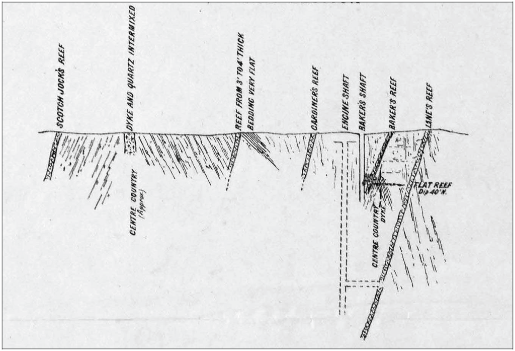
Referring to Whitelaw’s cross-section of Scotch Jock’s, Gardiner’s, Baker’s, and Lane’s Reef shown at right.
Note Lane’s Reef is on the eastern side of Baker’s anticline; the Whitelaw cross-section of Baker’s reef in Baker’s shaft depicts a cross fault in Baker’s anticline plunging at 23°.
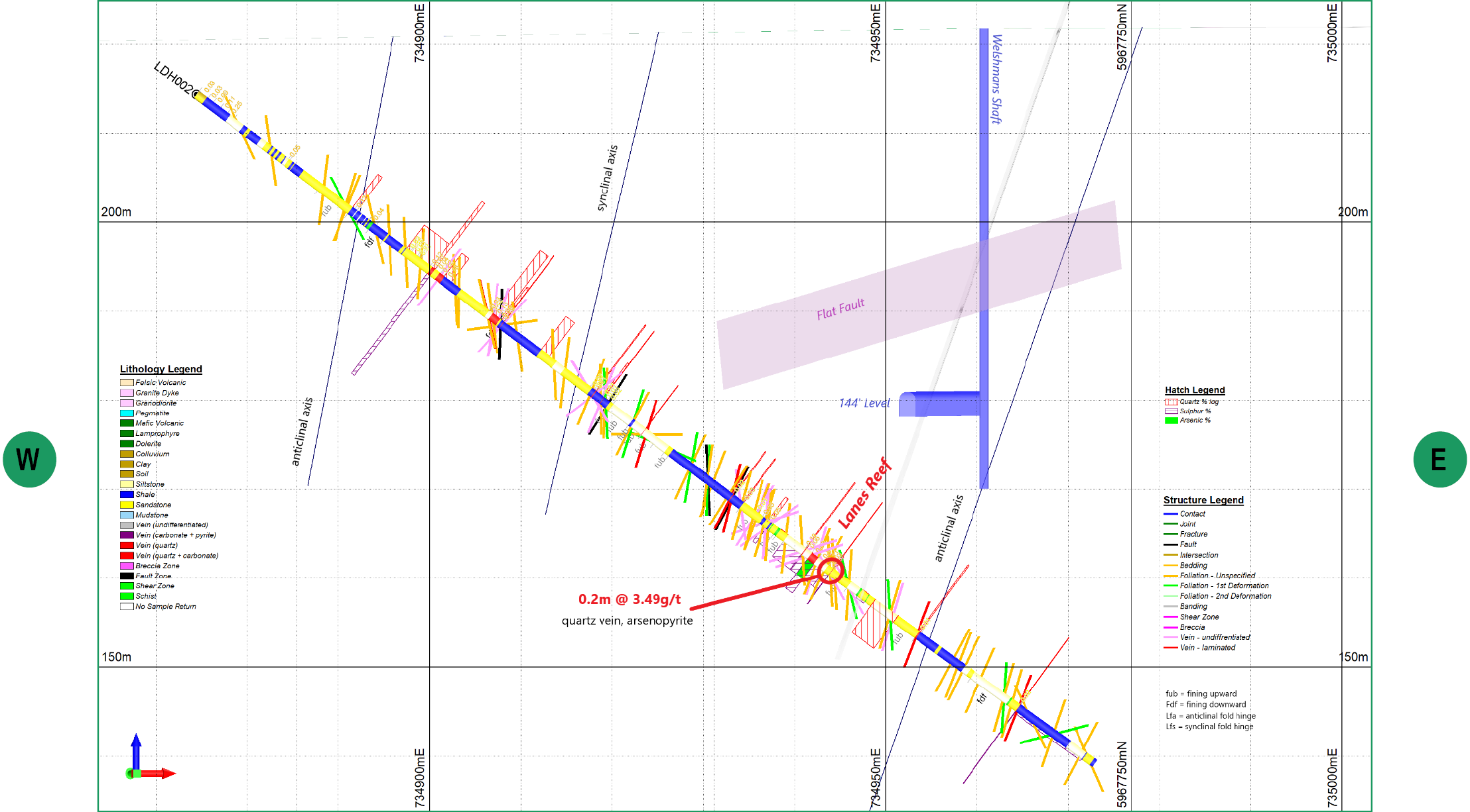
Looking at PSD Lanes corridor drill hole LDH002, Lane’s Reef is interpreted to be on the west of Baker’s anticline, if correct Lane’s reef has intersected:
- the 23° plunging cross reef (depicted in Whitelaw’s cross-section)
- the hinge of Baker’s anticline (depicted in Whitelaw’s cross-section)
The LDH002 drill log places Lane’s Reef on the west side of Baker’s anticline, whereas Whitelaw had Lane’s Reef on the east side of Baker’s anticline at Baker’s shaft further south.
The position, of this intersection area of both the cross fault and the hinge of Baker’s anticline, by Lane’s Reef now becomes exploration targets capable of being located underground more accurately.
Interpretation of the drill core from the current diamond drilling program is ongoing.
Magnetic and Conductivity Measurements
The reinterpretation of historical airborne magnetics by PGN has shown that an area of increased magnetic intensity occurs within the EL.
The figure at right depicts reduced-to-pole aeromagnetics extending outside the EL, covering an area some 15 km in length and 5 km wide, surrounded by different ages of granite outcropping.
PGN note: “Previously identified auriferous quartz reefs broadly correlate with North-South trending ~500 metre wide magnetic highs. – ….the ~500-metre-wide, magnetic anomalies are likely produced by folded magnetic horizons from the top ~250 metres of the subsurface.” (Not from within the oxidised zone.)
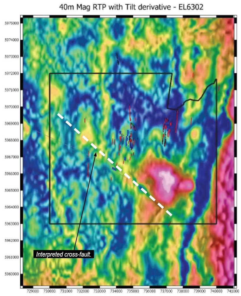
The airborne magnetics also define interpreted major linear cross faults within the EL, as shown at right.
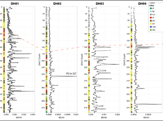
PGN note: “The cross faulting produces local magnetite/pyrrhotite depletion in the sedimentary pile. DH03 appears to be drilled across one of these cross faults with a zone of distinct brecciation, sodic alteration and arsenopyrite mineralisation at ~150-200 metres depth coincident with a depletion in magnetic susceptibility and wide zone (~100 metres) of increased conductivity. These relationships may be useful for targeting.”
PGN note: “Outcrop mapping and historic drilling suggest the Wedderburn region is dominated by the early Ordovician deep marine turbidites of the Castlemaine Group.”
The underlying Castlemaine Group is a prerequisite for gold deposition in the geological Bendigo Zone and thus on WGL’s EL.
Magnetics
The sedimentary rocks of Central Victoria, which host significant gold mineralisation, are part of a suite of rocks deposited in deep water, so they form subtle variations of siltstones, shales and sandstones that are quite difficult to log visually.
The magnetic susceptibility work by PGN has shown that at Wedderburn, different lithologies have distinct magnetic characteristics, potentially allowing for a more accurate interpretation of each lithology at right.
We believe this is a very important geological breakthrough that has potentially major ramifications for understanding the structural setting and prediction of major mineralised dilation zones.
Sandstones have the lower magnetic susceptibility, shale has an order of magnitude higher magnetic susceptibility, and siltstones have the highest magnetic susceptibility due to a narrow layer of pyrrhotite within siltstone.
The magnetic susceptibilities for the same lithology decrease as the structures move north in Lanes Corridor.
PGN note: “Where the magnetic response decreases along strike (N-S) we interpret this indicate plunging hinge zones or transition into synclinal hinges.”
“N-S trending aeromagnetic lows correspond to regional synclines where the siltstones rich horizons are structurally lower, producing a more subdued magnetic response due to increased source-to-sensor distance. This will require validation through structural logging”.
The magnetic susceptibilities will help define structure and lithology, which PGN will incorporate in the 3-D model it’s updating.
Lithology and Conductivity
Magnetic susceptibility and conductivity could provide useful tools to navigate the deformed sedimentary rocks within the EL.
The distinct magnetic signal of the region reflects folded sedimentary beds, which often have significantly contrasting magnetic susceptibilities.
Mineralised zones may have subtle petrophysical signals that could be elucidated in more detailed geophysical surveys.
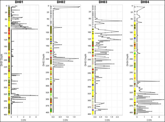
PGN Note: “The downhole hole conductivity analysis for DH01-4 reveals elevated conductivity for brecciated zones (xbx) and a wider zone of increased conductivity from 100 to ~226 metres in DH03, which is coincident with the most altered and arsenopyrite mineralised zone.
The most intensely altered zone sericite, arsenopyrite (~150- 180 metres interval) is characterised by a slight depletion in magnetic susceptibilities.
On this basis, it may be possible to image mineralised zones (xbx) with airborne electrical resistivity (TEM) or IP whilst the background shales, sandstones, siltstones, and rare dykes are not associated with any clear conductivity anomalies.”

